In Durango, be sure to ride the Durango & Silverton Narrow Gauge Railroad for some great views from the vantage point of a viewing window in a rail car perched on the edge of the mountain. You don't have to worry about mountain driving - you can just sit back and enjoy the ride. If you ride the open gondola, be prepared for your hair and clothes to be covered in a fine layer of coal dust when you reach the end of your trip. (Reservations recommended to get the seats you want.)
 |
| Riding along the Animas River, D&SNG RR |
 |
| Approaching Silverton on Highway 550 |
 |
| Headed down from Yankee Boy Basin |
We did not return by the paved road, however. We returned by Last Dollar Road and while 4-wheel drive isn't mandatory, a high clearance vehicle is and 4-wheel drive is recommended. From Telluride, we took 145 a short way back, turning on the road that leads to the airport (look for the sign). This road will branch shortly down the way from the turnoff, with the left option leading to the airport and the right option turning into Last Dollar Road (also known as T60). This drive winds and winds, goes over shallow, rocky creeks and shallow rock slides and at some point you will begin to wonder if you took the wrong road and you are never going to see civilization again. There are wonderful views of mountains, valleys and aspen groves and it is well worth the bouncy ride. You will be traveling through private property, so be careful of getting out and wandering too far off the road.
Eventually you will reach the end of the twisty little dirt road and you will find yourselves approaching Highway 62, just west of the lookout over Dallas Divide. Turn east and you will soon be back in Ridgway.
Little side note here. Large portions of the original True Grit motion picture were filmed in this area. There is a little cafe/bar named True Grit on the square in Ridgway. We did not eat there this time, but I've eaten there many times in the past. Not a bad place to stop for a drink after traveling on Last Dollar Road. It used to be full of atmosphere and I imagine it still is.
 |
| Looking back as we came to the end of Last Dollar Road |
 |
| The Visitor's Center at Black Canyon of the Gunnison National Park |
There are many, many places to stay in the Gunnison area, but I highly recommend going on to Almont and staying at Three Rivers Resort. It was a delightful 3 days we spent there. Turn north on Highway 135, which is also Gunnison's main street. Almont is about halfway between Gunnison and Crested Butte and three rivers come together there in a rush of white water. If you need groceries, stop in Gunnison before you head out because there are just the basics available in Almont.
The first full day we were there we made the scenic rounds in the Crested Butte area. From Almont, continue on Highway 135 north to Crested Butte. The first scenic drive we took was to Lake Irwin and you will take 12 (also known as the road to Kebler Pass) to reach Lake Irwin. Do not be fooled by maps that make it look like you can take the road all the way over Kebler Pass to Aspen. You can't. It is 4-wheel drive for a good long way but eventually it becomes impassable. This road is closed during winter.
Keep a lookout for signs indicating a turnoff to Lake Irwin and/or the Lake Irwin campgrounds. It's about 12 miles after you have left Crested Butte behind. The road up to the Lake is rough, so I wouldn't recommend trying to go by car. Once you have turned off the main road, it is another few miles up to the lake. There are picnic tables and composting toilets available and the freshest air you will ever breathe. A not-too-strenuous hike will take you down to a nice little waterfall. Folks are fishing and boating and sunning on rocks and camping a bit further up the road from the lake. It's a gorgeous place and well worth the trip.
 |
| Lake Irwin |
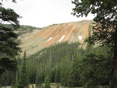
Keep driving past Gothic and you will soon be back in areas where you can explore a little. There are many little government campgrounds spotted along the road. They are all primitive campgrounds, so don't expect much in the way of amenities. If you keep on going, the road will take you to Schofield Pass and I think it pretty much ends there. Once you are well past Gothic, the road is in questionable shape, so again 4-wheel drive is recommended, You'll find yourself surrounded with beautiful mountain vistas and on the way back toward Mount Crested Butte, watch for the little meandering stream in the valley.
 |
| David checking out the stream in a valley just north of Gothic. |
When we descended the mountain and arrived in Pitkin, we turned onto 76, which led us back to US 50 about 15 miles or so east of Gunnison. There are a lot of scenic areas that you can detour to off 765, but do your research before you go. On my first trip we made the trip up to see the Alpine Tunnel and I'm still wondering why we thought we needed to do that. We made a slow drive up a mountain for something like 20 miles and saw a caved in tunnel with a historic information sign and then we had a slow 20 mile trip back down to the main road. Interesting? A bit. Scenic? Not so much.
 |
| Somewhere between Tin Cup and Pitkin |
LSW

No comments:
Post a Comment